
Emergency managers across the northern and eastern Gulf of Mexico from Louisiana to Florida are monitoring the progress of a north-northwest-moving storm system predicted to strengthen and possibly strike the Florida Panhandle as a Category 1 hurricane on Sunday.
The system formed in the Caribbean Wednesday and "is expected to become Tropical Storm Nate later today or tonight," according to the National Hurricane Center.
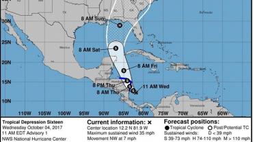
Tropical Depression 16 is located about 210 miles south-southeast of Cabo Gracias a Dios on the border of Nicaragua and Honduras, the weather service said in its 11 a.m. ET advisory.
The system has sustained winds of about 35 mph, moving northwest at 7 mph.
Gov. Rick Scott said Wednesday, “As we closely monitor this storm, it is so important for Florida families to remain vigilant, restock hurricane supply kits and ensure hurricane preparedness plans are in place. Based on current forecasts from the National Hurricane Center, we expect the storm to strengthen into Tropical Storm Nate today and move into the Gulf of Mexico this weekend. This storm has the potential to become a hurricane and impact the Florida Panhandle this weekend, and families must be ready."
"On the forecast track, the storm should be nearing the coast of Nicaragua early Thursday, move across northeastern Nicaragua and eastern Honduras late Thursday, and emerge into the northwestern Caribbean Sea on Friday," the NHC said.
The government of Nicaragua has issued a Tropical Storm Warning for the coast of Nicaragua from Sandy Bay Sirpi northward to the Honduras border. In Honduras, the government has issued a Tropical Storm Warning for the coast of Honduras from Punta Castilla eastward to the border with Nicaragua.
At present it looks like a particularly "wet" storm. Rainfall amounts of 15 to 20 inches are expected across portions of Nicaragua, with isolated maximum amounts of 30 inches and could cause "life-threatening flash floods and mudslides."
The system's proximity to, or possibly moving over land will keep it disorganized in the short term, but strengthening is more likely later Friday into Saturday as it moves northward, Fox News meterologist and weather producer Brandon Noriega has reported.
CNN is reporting NHC's forecast cone showing Nate may approach the eastern Gulf Coast near the Florida panhandle as a Category 1 hurricane by Sunday.
"While there is still some model disagreement on track and intensity, the Gulf Coast from Louisiana to the Florida Panhandle must closely monitor forecast updates and think about preparations as a strengthening tropical storm or hurricane may impact these areas on Sunday," Noriega said.
Nate would be the 14th named storm of the year, and come after a month of devastation from Hurricanes Harvey, Irma and Maria.
Forecasters said the Atlantic hurricane season would be "above-normal," with 14 to 19 by the peak season.
An average Atlantic hurricane season, which runs from June 1 to Nov. 30, produces 12 named storms, of which six become hurricanes, including three major hurricanes, according to the National Oceanic and Atmospheric Administration.
"Let’s remember, we are still in the heart of hurricane season," said Gov. Scott, "and while it’s hard to imagine experiencing another storm right now, everyone has to be prepared. We will continue to work with the National Hurricane Center to learn more as this storm develops and I encourage all Floridians to visit www.FLGetAPlan.org today to get prepared.”
Reach Nancy Smith at nsmith@sunshinestatenews.com or at 228-282-2423. Twitter: @NancyLBSmith
