
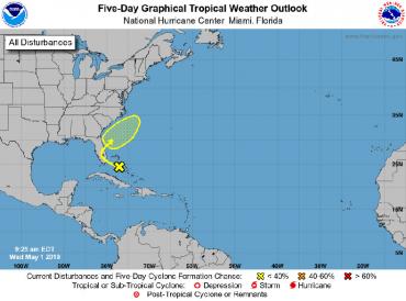
The National Hurricane Center (NHC) is giving an area of low pressure currently producing disorganized showers and thunderstorms over the Bahamas and moving toward Florida a 20 percent chance of developing into the first tropical storm of the year.
It's likely to take at least five days for that to happen, according to the NHC. The forecast, first hurricane season outlook of the year, is coming a full month before June 1, when daily tropical storm advisories begin.
NHC forecasters the low pressure system's over the western Atlantic toward the Sunshine State is slow and unlikely to build over the next 48 hours. But, they say, "the low’s counterclockwise flow together with an area of high pressure to its north" are creating a strong easterly wind blast toward the coast.
Florida can expect wet, windy weather beginning as early as Wednesday night, including the potential for urban flooding along the Gold Coast, Miami-Dade, Broward and Palm Beach counties, into Thursday.
Small craft and rip current warnings are in effect along most South Florida coastal communities at least through Thursday.
Reports the Palm Beach Post, "Wind gusts to 26 mph were recorded at Palm Beach International Airport overnight and could reach as high as 30 mph tonight through Thursday at the coast."
In April, Colorado state researchers predicted a slightly below average hurricane season.
The low over the southeastern Bahamas isn't expected to strengthen into a tropical depression or storm so early in the year, but should that happen, the storm would be named Andrea.
