
Hurricane Matthew has quickly intensified to a Category 4 hurricane and Florida is preparing for possible impact.
According to the National Hurricane Center, Matthew was heading towards the Caribbean as of Sunday, moving quickly towards Jamaica and Haiti before heading over Cuba and the Bahamas.
While the storm isn’t projected to hit Florida directly, the state’s east coast will be impacted by the storm -- at least for now. Weather forecasters still aren’t sure whether or not Matthew will change its path and move towards Florida.
Florida officials aren’t taking Hurricane Matthew lightly. Gov. Rick Scott warned Floridians to not write off the storm just yet.
“This is a serious and life threatening storm,” Scott said.
Scott was briefed Sunday on the developments of Hurricane Matthew as it moved through the Caribbean Sea and also spoke with county emergency management officials who are working to prepare for possible impacts from the storm.
“This storm is catastrophic, and if it hits our state, we could see impacts that we have not seen in many years,” Scott explained. “Even though the storm’s projected path is just east of our state, no one should take this lightly. Storms change fast and Hurricane Matthew could hit Florida as early as Wednesday.”
There had been no evacuations ordered as of Sunday evening, but Scott said that could change quickly and advised Floridians to stay alert.
“Hurricane Matthew continues to pose a significant threat to Florida,” said Florida Division of Emergency Management Director Bryan Koon. “I encourage everyone to take this potential threat seriously. Even if this storm does not make direct landfall, the significant risks of rip currents and severe weather will still exist.”
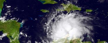
As of Sunday evening, the storm was still about 250 miles south of the southwest tip of Haiti and was expected to bring torrential rain to Haiti, Cuba and Jamaica over the next few days. The storm is projected to hit Jamaica and Cuba Monday and Tuesday and could lose some of its strength as a result of making landfall.
As of 8 p.m. Sunday evening, Hurricane Matthew had maximum sustained winds of 145 miles per hour with higher gusts.
Matthew is forecasted to head north and then east, but Florida isn’t entirely in the clear as the storm’s actual path could vary from 175 to 230 miles east or west of its current projected path.
“Although the official forecast continues to show a track east of Florida, it is still too soon to rule out possible hurricane impacts there,” the National Hurricane Center wrote Sunday evening.
Florida has already gone through hurricane preparations over the last few weeks. In September, Hurricane Hermine hit the Big Bend area, causing extensive damage, power outages and heavy rains.
State officials urged Floridians to have a safety plan and to prepare for the storm as they continued to monitor its progress.
Reach reporter Allison Nielsen by email at allison@sunshinestatenews.com or follow her on Twitter: @AllisonNielsen.
