
Watch Tropical Depression 4 through Mid-July
Submitted by Nancy Smith on July 6, 2017 - 6:17pm
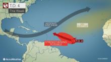
Tropical Depression 4 formed over the Atlantic late Wednesday evening and may remain a concern through the middle of July as it takes a path near the Lesser Antilles then near the East Coast of the United States.
Tropical Depression 4
As of Thursday morning, the center of the system was located over 1,250 miles east of the Lesser Antilles islands.
How quickly the system strengthens will determine its exact track.
The system will take a slow and general path around a clockwise flow of air associated with a large area of high pressure over the Atlantic Ocean.
"Should the system ramp up quickly to a tropical storm, it is more likely to turn to the northwest and slide north of the Leeward Islands this weekend," according to AccuWeather Tropical Meteorologist Brett Rossio.
"Should the system remain relatively weak and fail to become a tropical storm, it may take a more westward track, perhaps very close to the Leeward Islands this weekend," Rossio said.
Fluctuations in strength are likely. The degree of impacts on the islands in the northeastern Caribbean Sea will depend on the exact track and strength of the system as it passes by. Either way, a period of building seas, rough surf and squalls may spread westward through the Leeward Islands from Saturday to Sunday. Some impacts may occur in Puerto Rico on Sunday.
During the first part of next week, the system is likely to be traveling in waters near or just northeast of the Bahamas. During the period from July 12 to 16, the system is likely to be located somewhere from Bermuda to the shores of the southern Atlantic coast of the U.S.
Interests in these areas should closely monitor the track and strength of the system, especially during the dates mentioned. Impacts may range from a period of rough surf and frequent rip currents to heavy seas, flooding and damaging winds depending on the system's exact track and intensity.
Into this weekend, features that may limit the strength of the system include dry air, Saharan dust and strong west to southwest winds at middle levels of the atmosphere, called wind shear.
Comments are now closed.

Live streaming of WBOB Talk Radio, a Sunshine State News Radio Partner.